Huracan Emily
Hurricane Emily is the fifth storm of the 2005 Atlantic hurricane season and the earliest fifth named storm on record in the Atlantic basin. The storm passed through the Windward Islands, where it caused moderate to severe damage in Grenada. Emily then made landfall in Mexico, first on the island of Cozumel and then just north of Tulum on the mainland of Quintana Roo, and later threatened the northern state of Tamaulipas and southern Texas in the United States.
On July 16, Emily became the strongest hurricane ever to form before August (beating a record set by Hurricane Dennis just nine days before on July 7, 2005) when its sustained winds increased to 155 mph (250 km/h), which placed Emily on the verge of Category 5 intensity on the Saffir-Simpson Hurricane Scale.
Emily made landfall near Tulum on Mexico's Yucatán Peninsula as a Category 4 storm on July 18.
Contents
[hide]
* 1 Storm history
* 2 Impact
* 3 Current
* 4 Official forecasts and information
Initially forecast to strengthen rapidly and move west-northwest through the Greater Antilles, Emily instead moved almost due west toward the Windward Islands, remaining a moderate tropical storm.
The storm languished while moving quickly west, and struggled with maintaining its form. Contrary to the normal occurrence that hurricanes leave a cold wake behind, Hurricane Dennis made portions of the Caribbean Sea warmer, and therefore more favorable for tropical cyclone development. Late on July 13, it strengthened rapidly and reached hurricane strength while passing Tobago and entering the western Caribbean. On July 14 Emily made landfall in northern Grenada.
The intensification trend picked up again the next day with a fairly rapid drop in the storm's central pressure as it entered the southeastern Caribbean Sea, a region typically unfavorable for intensification. Hurricane Emily's winds increased in reaction, briefly bringing the storm to Category 4 strength early on July 15. During the day, the storm's strength fluctuated greatly, dropping to a Category 2 storm and then rebuilding to Category 4. On July 16, Emily strengthened considerably, making it the strongest hurricane ever on record to form in the month of July. The storm's winds increased to 155 mph (250 km/h), just under Category 5 strength, and stayed at this strength for the rest of the day while passing south of Jamaica and, on July 17, the Cayman Islands.
Hurricane Emily continued on its nearly straight track to the west-northwest, weakening somewhat but remaining at Category 4 until striking Cozumel just before mainland landfall near Tulum at 2:30 am EDT on July 18. Sustained winds were 135 mph (230 km/h), and the eyewall passed directly over Cozumel.
The center of circulation emerged over the Gulf of Mexico later that morning. Passage over land disrupted the hurricane's center of circulation, and it had weakened to a minimal hurricane. However, several hours over the warm waters of the western Gulf provided the energy needed for Emily to regenerate, and by midnight wind speeds were increasing. The increase in wind speed stalled, but the storm continued to become better organized. Emily started to show very symmetrical outflow, but the hurricane's strongest winds were being found at 3 different distances from the center. However, the outer wind radii subsided in the end, and the inner core prevailed. The result was a rapid strengthening of the inner core on the evening of the 19th. The pressure droped about 30 millibars and the winds went from 90 mph to more than 125 mph, all within a few hours.
Current
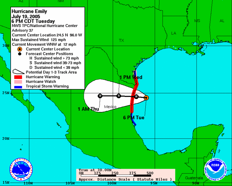
3-day forecast for Hurricane Emily on July 19, 2005 at 4 PM CDT
Enlarge
3-day forecast for Hurricane Emily on July 19, 2005 at 4 PM CDT
As of 6 pm CDT on July 19 (2300 UTC), the center of Hurricane Emily was over the Gulf of Mexico, 105 miles (168 km) east of Bahia Algodones, Tamaulipas, and 135 miles (215 km) southeast of Brownsville, Texas. The storm had slowed to moving west-northwest at 12 mph (19 km/h), and had restrengthened to be a major Category 3 hurricane with maximum sustained winds of 125 mph (205 km/h).
Emily is likely to remain a major hurricane until final landfall in the state of Tamaulipas in the early hours of Wednesday July 20. Further strengthening is expected.
Watches and warnings:
* Hurricane warnings are in effect for:
o La Cruz, Tamaulipas, north to Port Mansfield, Texas.
* Tropical storm warnings are in effect for:
o Baffin Bay in Kenedy County, Texas, south to Port Mansfield.
o Cabo Rojo, Veracruz, north to La Cruz.
* Hurricane watches are in effect for:
o Baffin Bay, Texas, south to Port Mansfield.
posted by Cave Man. @ martes, julio 19, 2005
3 comments
![]()


3 Comments:
Good design!
[url=http://naiugtyr.com/sozn/pihv.html]My homepage[/url] | [url=http://edgvzppr.com/fplx/xlxc.html]Cool site[/url]
Nice site!
My homepage | Please visit
Great work!
http://naiugtyr.com/sozn/pihv.html | http://mtxftljg.com/gwlp/qcuw.html
Publicar un comentario
<< Home